
How a Topographic Survey Is Used for Landscaping and Grading Projects
Bad Grading Starts Before Anyone Breaks Ground
Water pools where it shouldn’t. Soil shifts. Retaining walls crack. Most of those problems trace back to one decision made before construction started. Someone skipped the survey.
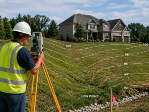
A topographic surveyor maps the shape of the land. It shows slopes, low spots and elevation changes across a site. For developers, that data drives every grading and landscaping decision. Skip it, and you’re guessing. Get it done, and you know exactly what you’re working with.
It records the physical features of a piece of land. That includes:
- Ground elevation at multiple points
- Slopes and grade changes
- Existing drainage patterns
- Trees, structures and other surface features
- Utility locations (in some cases)
Surveyors use this data to create contour lines on a map. Each line marks a specific elevation. The closer the lines, the steeper the slope.
Why Contour Lines Matter for Grading
Grading changes land elevation on purpose. You cut high spots down. You fill low spots up. Contour lines tell you how much work that takes.
Without them, a contractor is estimating. With them, they’re calculating. That difference shows up in your budget and your timeline.
How Developers Use Topographic Data for Landscaping
Landscaping isn’t just about looks. For a developer, it’s about drainage, erosion control and long-term site performance.
A topographic survey shows where water naturally flows across a site. That shapes every decision about:
- Where to place planting beds
- Where to install drainage structures
- How to grade lawns and common areas
- Where retaining walls are needed
Matching the Landscape Plan to the Land
Plans look flat on paper. Real terrain is not. A topo survey closes that gap. The designer sees the actual land, not an assumption about it.
That means fewer change orders. Less rework. A finished site that drains the way it should.
Grading Plans Depend on Topographic Data
A grading plan tells contractors how to reshape land. It shows cut and fill areas, finished grade elevations and slope targets.
You can’t write a grading plan without a topographic survey. It’s the base layer.
Here’s what the grading engineer pulls from the survey:
- Existing elevations across the site
- Natural drainage paths
- Slope percentages
- Problem areas like low spots or steep drops
Cut and Fill Calculations
Moving dirt costs money. The goal is to balance cut (removing soil) and fill (adding soil) so you’re not hauling material off-site or importing it.
A topo survey gives the numbers needed to calculate that balance before work starts. That saves time and reduces cost.
Common Problems a Topographic Survey Prevents
Developers who skip a topo survey often run into the same issues:
- Standing water after rain
- Erosion on slopes
- Grading that doesn’t meet local drainage codes
- Retaining walls built in the wrong spot
- Landscaping that fails because drainage is off
Each of those problems costs money to fix. A survey costs far less than a fix.
Drainage and Code Requirements
Many local governments require grading plans to show that stormwater stays on-site or drains to an approved outlet. A topo survey gives you the data to prove that. Without it, your grading plan may not pass review.
When to Order a Topographic Survey
Order it before design starts. Not after.
Some developers wait until they have an early plan in hand. That’s backwards. The survey should shape the plan, not react to it.
The best time to get a topo survey is right after you close on a piece of land. That way, your civil engineer, landscape architect and grading contractor all start with the same accurate data.
Frequently Asked Questions
What is a topographic survey used for in landscaping?
It shows the shape of the land, including slopes and drainage patterns. Landscape designers use that data to place plants, drainage structures and grading correctly.
Do I need a topographic survey before grading?
Yes. A grading plan requires existing elevation data. A topo survey provides that. Without it, grading calculations are based on guesses.
How accurate is a topographic survey?
A survey done by a licensed land surveyor is accurate to within a fraction of a foot. That level of detail matters when calculating slopes and drainage.
How long does a topographic survey take?
It depends on the size of the site. A small to mid-size lot can usually be surveyed in one day. Larger sites take longer.
Can I use a topographic survey for permit applications?
Yes. Many local permits for grading, drainage and site work require a topo survey as part of the application package.
For a free land surveying quote, call us at (954) 516-2680 or send us a message by going here.
Posted in land surveying, land surveyor |