
Land Mapping Drones for Large Yard Layouts
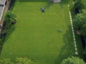
Land mapping drones capture an entire large yard in minutes, showing every slope and low spot at once. For developers planning a big yard layout in Hollywood, that full picture changes how you place pools, patios, and drainage before any digging starts. This guide covers what makes a large yard layout different from a small one, how drones capture that space, and where the data still needs a ground check.
What Makes a Large Yard Layout Different From a Small One
A small yard usually needs one or two design decisions. A large yard needs a full plan. Where does the pool go? Where does the patio sit relative to drainage? Where does a fence line run without crossing a low spot that floods after rain?
These decisions all depend on accurate elevation data across the whole space. A large yard often has more grade change than people expect, even on a lot that looks flat from the ground. Missing this detail early leads to costly fixes once construction starts.
How Land Mapping Drones Capture a Big Yard Quickly
A drone flies over the yard and captures elevation data across the entire space in one flight. This turns into a detailed map showing every rise and dip, instead of just the handful of points a person might measure by hand with a level.
This matters most on large lots. Walking a big yard and taking manual measurements takes hours. A drone covers the same ground in minutes, giving a designer a complete picture before any layout decisions get made.
Using Drone Data to Plan Yard Zones and Hardscape
A large yard often gets divided into zones. One area for a pool. Another for a patio or outdoor kitchen. Another left open for lawn or landscaping. Drone elevation data shows which zones sit on stable, well-drained ground and which zones sit in a low spot that collects water.
This data also helps place hardscape features like retaining walls or raised patios. Knowing the exact grade change across a yard lets a designer plan these features to work with the natural slope, instead of fighting against it after construction begins.
Spotting Drainage and Grading Issues Across a Large Lot
Flat Florida yards often hide small grade changes that decide where water goes during a storm. A drone survey reveals these changes across the full yard, showing exactly where water collects and where it drains naturally.
This is especially useful before adding hardscape. A new patio or pool deck can block a natural drainage path if it gets placed without checking the existing grade first. Drone data catches this risk before the concrete gets poured, not after.
Documenting Existing Trees and Vegetation Before Layout Changes
Large yards often have established trees, hedges, or landscaping that a new layout needs to work around. A drone survey documents all of this across the property, giving the designer a clear record of what exists before any changes begin.
This record also helps if a permit process asks about tree removal or protected vegetation. Having a clear aerial record from before construction started can prevent disputes later about what was actually there.
Steps to Use Land Mapping Drones for a Yard Layout Project
- Schedule the drone flight during calm, dry weather for the most accurate elevation data.
- Confirm the flight covers the entire yard, including any areas near the property line.
- Ask for the elevation data in a format your landscape designer or engineer can use directly.
- Compare the drone data against your layout plan to check for low spots or drainage conflicts.
- Keep the drone documentation on file in case a future permit or dispute needs a record of prior conditions.
Where Drone Mapping Still Needs Ground Confirmation
Drone mapping covers a large yard fast, but it doesn’t replace every step of a full survey.
- Thick tree canopy can block the drone’s view of the ground beneath it, leaving gaps in the elevation data.
- Underground utilities and irrigation lines don’t show up in drone imagery, so existing utility maps still matter before digging begins.
- Confirming an exact property line still needs a licensed ground survey, since a drone shows the yard’s surface, not the certified legal boundary.
Drone mapping handles the large-scale layout and grading work well. It still needs to pair with traditional survey steps for anything involving legal boundaries or underground work.
Frequently Asked Questions
How long does it take to map a large yard with a drone?
Most residential properties can be mapped in less than an hour, although larger lots may require additional flight time. Processing the collected data into maps and elevation models takes extra time after the flight.
Can drone mapping replace a full property survey for a yard layout project?
No. Drone mapping provides detailed surface elevations and site features, but legal boundary locations, easements, and underground utilities still require traditional surveying methods or existing records.
Does tree cover affect the accuracy of drone mapping for a yard?
Yes. Dense tree canopy can block the drone’s view of the ground, creating gaps in the elevation data. These areas may require additional ground surveying to verify site conditions.
How does drone mapping help prevent drainage problems in a yard design?
Drone mapping identifies subtle slopes, low areas, and natural drainage patterns across the property. This information helps designers place landscaping, patios, and other improvements where they are less likely to create drainage issues.
Is drone land mapping useful for a yard that appears completely flat?
Yes. Even yards that appear level often have small elevation changes that influence how water drains. Drone mapping captures these subtle grade differences before landscaping or construction begins.
For a free land surveying quote, call us at (954) 516-2680 or send us a message by going here.
Posted in land surveying, land surveyor | Tagged LiDAR Mapping