
What a Topographic Survey Shows on Flat Lots

A lot in Hollywood, Florida can look flat. You walk the property, and everything seems level. No hills, no dips, nothing unusual.
Then construction starts, and problems show up.
Water sits where it shouldn’t. The driveway slope feels off. Parts of the yard stay wet longer than expected. These issues don’t come from bad luck. They come from small elevation changes that are hard to see without proper data.
A topographic survey shows what the land is actually doing. It gives you a clear picture before any building begins.
Why “Flat” Lots in Hollywood Can Be Deceptive
South Florida terrain plays tricks on the eye. Most properties do not have large elevation changes, so everything looks simple. Still, even a few inches of difference can affect how water moves and where structures should sit.
Hollywood also gets heavy rain. When that water hits your property, it follows the natural slope. If the slope is not what you expect, water can move toward your house instead of away from it.
That’s where many problems begin. The land may look flat, but it still has direction.
What a Topographic Survey Actually Shows
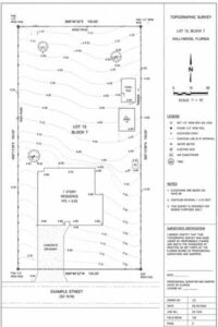 A topographic survey maps the surface of your property in detail. It doesn’t just mark corners or boundaries. Instead, it shows how the ground rises and falls across the entire lot.
You’ll see elevation points placed throughout the property. These points connect to form contour lines, which show the shape of the land.
The survey also captures:
- Slopes across the lot
- Low areas where water can collect
- High points that affect grading
- Existing features like driveways, trees, and structures
This information helps your builder and engineer understand how to work with the land, not against it.
Small Elevation Changes That Cause Big Problems
Most issues on flat-looking lots come from minor elevation shifts. These are easy to miss during a walkthrough.
A slight dip in the yard might not stand out on a dry day. After a storm, that same area can hold water for hours or even days.
A gentle slope toward the house can lead to drainage problems near the foundation. Over time, that can affect the structure or create ongoing maintenance issues.
Without a topographic survey, these details stay hidden until construction is already in progress.
How Slope Affects Your Driveway and Foundation
Driveways need the right slope to function well. Too steep, and they become hard to use. Too flat, and water may not drain properly.
A topographic survey shows the exact slope so your design can match the land. That helps avoid awkward angles or drainage issues later.
The same applies to your foundation. The finished floor height depends on the surrounding ground. If the elevation is off, you may need extra grading work to correct it.
That adds time and cost, especially if the problem shows up late.
Low Areas That Limit What You Can Build
Every lot has areas that are more usable than others. On flat properties, these differences are not always obvious.
A topographic survey highlights low spots that may stay wet or soft. These areas might not be ideal for structures, patios, or heavy landscaping.
When you know this early, you can adjust your layout. You place structures on stable ground and plan outdoor spaces where they will hold up over time.
Skipping this step often leads to changes during construction, which slows everything down.
Existing Features That Change Your Plan
Your lot already has features that affect how you build. These include trees, pavement, fences, and nearby structures.
A topographic survey maps these features along with their elevation. That matters more than most people expect.
For example, a driveway that looks level might sit higher than the surrounding ground. That can affect how water flows across the property.
Trees may also sit on uneven ground, which impacts grading plans. Without this data, design decisions rely on guesswork.
Why Builders Ask for This Early
Builders and engineers want accurate information before they finalize plans. A topographic survey gives them that starting point.
When they know the exact elevations, they can design grading, drainage, and layout correctly from the beginning.
This keeps the project moving. It also reduces the need for changes once work starts.
Delays often come from surprises. A topographic survey helps remove those surprises.
Common Mistakes on Flat Lots
Property owners often assume their lot is simple because it looks flat. That leads to a few common mistakes.
Some start designing before understanding the land. Others rely on rough measurements instead of detailed data.
There are also cases where people copy a neighbor’s layout. That rarely works because each lot has its own elevation pattern.
These choices can lead to redesigns, extra grading, and delays during construction.
What You Get from a Topographic Survey
Once the survey is complete, you receive a detailed map of your property. This includes elevation points, contour lines, and surface features.
Your builder and engineer use this map to plan the project. It becomes the reference for grading, layout, and drainage decisions.
Instead of guessing, you’re working with real numbers.
That makes every step more predictable.
Building Starts with Knowing the Land
Flat doesn’t always mean simple. In Hollywood, small elevation changes can affect how your entire project turns out.
A topographic survey shows what your eyes can’t. It helps you plan with confidence and avoid problems that only show up later.
When you understand the land first, everything else falls into place.
For a free land surveying quote, call us at (954) 516-2680 or send us a message by going here.
Posted in land surveying, land surveyor |