
Can Tree Removal Affect Property Line Evidence?
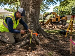
Tree removal looks like a simple site prep task. Cut down the trees, grind the stumps, start grading. But in Florida, removing trees without a property line survey first can destroy boundary evidence that took decades to establish. Once that evidence is gone, recovering the property line costs more time and money than the tree work itself.
Why Trees Can Serve as Boundary Evidence
Trees don’t show up on recorded plats. But they can still be legal evidence of a property boundary.
In Florida, a tree that has stood along a boundary line for decades may have been planted there intentionally. Prior owners sometimes used tree rows to mark the edge of their land before iron pins existed or before a formal survey was done. Courts and licensed surveyors can treat that kind of physical evidence as corroborating support for a boundary location.
A tree can also grow around an iron pin. Roots wrap the metal. The pin gets buried under years of organic material at the base of the trunk. The tree itself becomes the visible marker pointing to what’s underneath.
In Hollywood’s older residential areas, neighborhoods platted in the 1940s and 1950s have exactly this situation. Original iron pins are buried, shifted or gone. What remains on the ground sometimes includes mature trees that have stood in the same spot for 60 or 70 years.
When a Tree Qualifies as Boundary Evidence
Not every tree is boundary evidence. A licensed surveyor evaluates trees based on:
- Their position relative to the recorded plat dimensions
- Their age in relation to when the property was first surveyed
- Whether they align with other found monuments on the same boundary
- Whether neighboring surveys reference the same trees as control points
A tree that lines up with the recorded plat and matches found monuments on adjacent parcels carries real evidentiary weight. Cutting it down without documentation removes that weight permanently.
How a Property Line Survey Documents Existing Site Evidence
A property line survey done before any site work captures everything on the ground.
A licensed surveyor photographs and measures the position of trees near the boundary. They note which trees appear to align with recorded plat dimensions. They record the species, approximate age and exact position of any tree that may serve as corroborating evidence for a corner or line.
That documentation goes into the survey file. If a boundary is ever challenged, the surveyor’s field notes and photographs show what the site looked like before construction or clearing began.
Under Florida Administrative Code Chapter 5J-17, licensed surveyors must document all evidence used to locate a boundary. Physical features on the ground, including trees, fences and old improvements, count as evidence when they support or conflict with the recorded description.
Getting the survey done before site prep is not extra caution. It’s how you protect the boundary record.
What Happens When Longstanding Trees Are Removed
When a long-standing tree gets removed without prior survey documentation, two problems can follow.
First, the iron pin or monument beneath or near the tree may be destroyed during stump grinding. Stump grinders work at ground level and below. A buried iron pin within a foot of the stump gets chewed up. That pin was set by the original surveyor when the plat was recorded. Replacing it requires proportionate measurement under Florida Administrative Code Chapter 5J-17, which takes more time and carries more professional uncertainty than simply using the original monument.
Second, the physical evidence that supported the boundary location disappears. If a neighbor later disputes the line, the surveyor who comes out to investigate has less to work with. A tree that corroborated the boundary position no longer exists. The dispute becomes harder to resolve and may require title research going further back in the ownership chain.
In dense residential areas of Hollywood, where lots are small and boundaries are close to structures, that kind of dispute gets expensive fast.
Recovering Property Boundaries After Landscape Changes
When trees and stumps are removed before a survey, recovery is still possible. It just takes more work.
A licensed surveyor starts with the recorded plat and the legal description. They look for any remaining monuments on the subject parcel and on adjoining parcels. They pull surveys of neighboring properties to see if those surveys located any of the same monuments or trees before the clearing happened.
Historical aerial photography can sometimes fill in gaps. Broward County’s property appraiser and geographic information systems hold aerial images going back several decades. A surveyor can use those images to identify where large trees stood relative to structures and known boundary features.
None of this is as clean as having the original evidence on the ground. Proportionate measurement from distant control points introduces more uncertainty than a found monument at the actual corner. The survey can still be done, but the margin for error is wider.
Why a Property Line Survey Should Come Before Tree Removal
The sequence matters. Survey first, then remove trees.
When a licensed surveyor documents the site before any clearing, the boundary record is protected. Iron pins near trees get located and marked above ground before stump grinding begins. The field crew flags the exact positions of monuments so equipment operators know where not to work.
If trees are serving as boundary evidence, the surveyor notes that in the file and photographs their positions relative to found monuments and plat dimensions. That record survives the clearing.
For developers assembling lots or clearing land for new construction in Hollywood, this step is not optional. Broward County permit applications require accurate boundary information. A boundary compromised by cleared evidence is a problem that shows up at the permit review stage or, worse, during a title search before closing.
Order a property line survey before any tree removal starts on a development site. The survey cost is small. Recovering a destroyed boundary is not.
Frequently Asked Questions
Can tree removal destroy property line evidence?
Yes. Trees near property boundaries can help identify buried survey monuments or serve as supporting evidence during a property line survey. Removing trees or grinding stumps may disturb or destroy that evidence, making it more difficult and expensive to re-establish the boundary.
Do all trees near a property line count as boundary evidence?
No. A licensed surveyor evaluates each tree based on its location, age, relationship to the recorded plat, and how it aligns with other boundary evidence. Only trees that support the documented boundary location have evidentiary value.
What should a property owner do before clearing trees on a site?
Schedule a property line survey before any tree removal begins. The surveyor can locate and mark property corners, document existing boundary evidence, and record the position of trees or other features that may help establish the property’s legal boundaries.
What happens if survey monuments are destroyed during tree removal?
If survey monuments are disturbed or destroyed, the surveyor must re-establish the missing property corners using accepted surveying methods and documented research. This process typically requires more time and may increase the cost of the survey.
Does a property line survey affect a permit application?
Yes. Many permit applications require accurate boundary information. A property line survey helps verify legal property boundaries, supports site planning, and reduces the risk of delays caused by boundary questions during permitting or future property transactions.