
How Survey Mapping Helps Prevent Utility and Drainage Problems
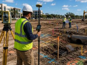
A broken water main mid-excavation costs more than the repair bill. It stops work for days. It brings fines. It leaves your crew standing around doing nothing. Most of those situations start the same way: nobody ran survey mapping before the shovels went in. For developers, accurate site data before any ground work is what keeps a project on track.
Why Accurate Site Mapping Matters Before Any Project
Developers who skip early site mapping find out why it matters the hard way.
A site plan built from old records will miss what’s underground. Utility lines get moved over the years. Drainage systems get changed. Old plat maps don’t show easements added after the original subdivision was built.
In Broward County, one site can have utility lines from several different agencies. The City of Hollywood and private utility companies each keep their own records. None of those records show up on one single map. A licensed surveyor pulls from all of them and checks what’s actually in the ground.
Finding problems before permits are pulled costs much less than fixing them in the field.
How Survey Mapping Identifies Existing Utilities
Underground utility mapping is one of the most useful things a developer gets from a full survey.
A surveyor finds and records:
- Water mains and service lines
- Sewer lines and manholes
- Storm drain pipes and inlets
- Electric and communication conduits
- Gas lines
All of that gets drawn on a scaled map tied to the legal boundary of the site. You can see exactly where each utility runs compared to your building footprint, driveways and grading plan.
Florida Statute 556 says anyone digging must call 811 first. That call sends utility companies out to mark lines with spray paint. Survey mapping goes further. It records locations in a way that works in engineering drawings, gets shared with contractors and stands as a legal record.
Paint marks on the ground work fine for a homeowner. For a developer pouring a foundation, they’re not enough.
Using Survey Data to Plan Effective Drainage
Drainage planning without elevation data is a guess. Survey mapping gives you real numbers to work with.
A topographic survey records existing grades across the whole site. The surveyor takes spot elevations and maps contour lines. That shows how water moves across the property right now. Engineers use that data to build the drainage design.
The South Florida Water Management District (SFWMD) controls stormwater rules for most projects in Broward County. SFWMD permit applications require proof that runoff after development won’t exceed what the site produced before. You can’t show that without real elevation data.
Survey mapping also finds:
- Low spots where water sits after rain
- Existing drain lines that must stay or get moved
- Outfall points tied to the public drainage system
- Easements on drainage infrastructure that block certain construction
If the drainage design is wrong, SFWMD will reject the permit. That sets you back months.
Common Problems Caused by Incomplete Site Information
Skipping early site data leads to problems that show up on nearly every project where it happens.
Utility conflicts come up most often. A building pad gets placed without knowing a water main runs right through it. Moving that main after permits are issued costs money and time. It also means working around the utility company’s schedule.
Drainage failures are next. A site plan assumes water flows toward the street. The real grade slopes toward the neighbor’s lot. After the concrete goes in, the first big rain floods the property next door. That’s a legal problem on top of a construction one.
Easement violations happen after the fact too. A drainage easement crossing a parcel may not show up in a basic title search. Survey mapping puts those easements on the drawing before any design gets locked in.
Some easements ban permanent structures entirely. Building inside one can void permits or delay a certificate of occupancy.
All of these problems are avoidable. The right data up front prevents all of them.
Why Early Survey Mapping Saves Time and Money
The best time to find a problem is before you’ve built around it.
Survey mapping at the start of a project gives everyone a shared, accurate base. Engineers use it for drainage and utility design. Architects use it to place the building correctly. Contractors use it to plan digging. Everyone works from the same verified data.
In Hollywood, older neighborhoods are being redeveloped and infill lots are common. What’s in the ground rarely matches what old records show. Utility lines date back decades. Drainage has changed as nearby lots were built up. Assuming the site matches old records is a mistake that gets repeated constantly.
A topographic and utility survey usually takes one to two weeks. That’s a small amount of time compared to a permit rejection, a redesign or a damaged utility line mid-construction.
Order the survey before the site plan gets finalized. Don’t wait until design decisions are already made.
Frequently Asked Questions
Can survey mapping find utility lines that utility companies don’t have on record?
Yes. Older sites in Hollywood and similar redeveloped areas sometimes have lines that predate current record systems. A licensed surveyor looks for physical clues like valve boxes, cleanout caps and surface markings. That field check often catches what a records search misses.
What happens to survey mapping data when a utility gets moved during construction?
The original survey becomes outdated once a utility moves. Smart project teams order an updated as-built survey after any relocation. That updated record protects the developer if a future contractor damages the moved line and claims no record existed.
Does a topographic survey show drainage problems on a dry day?
Yes. A topographic survey records grades precisely enough for engineers to model water flow with math. They run drainage calculations off those numbers to predict what happens during a storm, even when the site is dry during the survey.
How does survey mapping affect where a detention or retention pond gets placed?
Pond placement depends on available grade and proximity to existing outfalls. Survey mapping supplies the elevation data that shows where a pond can sit and whether gravity flow to an outfall is possible. Without that data, pond placement in the design phase is a guess that often gets changed later at real cost.
What’s the risk of using county GIS data instead of commissioning a survey?
County GIS data is a reference tool. It’s built from records of different ages and accuracy levels. It carries no legal certification. GIS utility layers can be off by several feet. Elevation data in county systems often lacks the detail needed for drainage design. Permitting agencies and title insurers don’t accept GIS output in place of a sealed survey from a licensed Professional Surveyor and Mapper.
For a free land surveying quote, call us at (954) 516-2680 or send us a message by going here.
Posted in land surveying, land surveyor | Tagged Survey Mapping
Land Surveying: Estimating the Cost

Copyright (c) 123RF Stock Photos
Land surveying, in short, is the science and art of establishing or re-establishing property corners, property lines and/or boundaries. There are different reasons why someone wants a lot surveyed.
Essentially the most common is to check if a piece of land is vulnerable to flooding, to subdivide a property to sell or deed to family members as well as to determine if there are any encroachments. This may happen if a neighbour disputes that you are using a piece of his lot or viceversa (for more on this, go here).
The Cost of Land Surveying
If you need to have a piece of land surveyed, the first thing that will come to mind is “how much will it cost?”There are plenty of factors determining exactly how much land surveying for your land would cost.
The fact that this type of service must be carried out by an expert contributes a great deal to the overall cost of the service, but choosing a non-professional to survey your land is dangerous and possibly illegal for the non-professional. Because of this you have to take a good look around before settling with a surveying company.
If you must work within a particular budget, discuss this with the surveyor up-front. Very often he may be able to offer cost saving steps to get the work you need done within these cost limits. The form of the land must also be looked into. A square or even a rectangle piece of land is somewhat easier to survey than an odd shaped parcel, or one with many different sides.
With the latter, the surveyor would have to take more time in surveying the curves as well as the bends which means the cost of the service would go higher.
The overall measurements the land is also key factor here. Understand that the cost of land surveying is normally proportionate to the time and effort that the land surveyor would spend on the project. If the land that you’re having surveyed isn’t accessible, or has thick vegetation, then the total price of the survey might go higher.
This is true of the varying weather conditions that might impact the work. Surveying in warm weather is somewhat slower to keep from putting the crew members in danger. Also, most surveying can’t be done in the rain.
When requesting for an estimate, bear in mind that surveyors base the estimate on expected conditions at the site. These conditions could change, bringing about additional costs. Always ask about these potential additional cost scenarios.
All that being said, competitive prices are also to be expected, this is why we recommend deciding on a surveyor based upon his experience and reputation rather than on the price he writes on a piece of paper. Usually it is better to invest a good amount of money on a survey that’s well-done rather than choose a company with a very “affordable” price but have the survey repeated because the results were wrong.
To sum it up, you should always discuss the expenses of the survey before you decide to ask the surveyor to start his work. It’s also wise to receive a contract that lets you know what is expected of the land surveyor. This is one of the most important steps in getting your land surveyed.
For a free land surveying quote, call us at (954) 516-2680 or send us a message by going here.
Posted in land surveying, land surveyor | Tagged cost of land surveying, estimating the cost of land surveying, land surveying cost, land surveying cost Hollywood